Sunday, September 20, 2009

An afternoon of geocaching and benchmark hunting

Saturday afternoon I wanted to do some caching, but I also needed to get my car inspected and the oil changed. It turns out that Jiffy Lube has free WiFi, so I fired up GSAK and loaded some waypoints into my laptop. When my car was done, I started with the nearest waypoint:


FY1903 WITCH
An easy benchmark to get started. It's at the edge of the parking lot of a restaurant supply company. Someone has painted a big arrow on the pavement, making it hard to miss. (Incidentally, I realized at this point that I had forgotten my digital camera. I was stuck making photographs with my Blackberry.)


The datasheet says it's flush with the surface... but I had to clean a half-inch of dirt off it. The datasheet also says it's marked "WITCH," but it actually says "WITCHY."

Next on the list were a couple of geocaches. Two quick park n' grabs in the same parking lot.
GC14A06 Pole Position
GCIW18T At the Crossing

After signing those two logs, it was on to search for a benchmark. FY1904 FRASIER. The last recovery for this one was in 1977, and the NC Geodetic Survey reported it as DNF in 1994. The coordinates are "Adjusted" so they should be spot on. And they place it right in the right-turn lane of N. Duke St. All of the reference points mentioned in the description are gone. I can only conclude that the mark was destroyed when Duke Street was widened, sometime between 1977 and 1994.


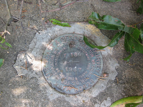
FY1905 CARVER was a pleasant surprise...I was looking at the NGS datasheet, and not the logs on geocaching.com. The 1994 recovery note says "mark is now recessed 8 inches below the ground." I was expecting to log a DNF because I wasn't equipped to dig, but I found it at the bottom of a hole in the ground.


After a couple of benchmarks and a couple of microcaches, I was ready for a bigger geocache. One where I could leave a trade item and take a souvenier. On to GCTYX4, named in honor of one of my favorite ex-Presidents. The container was big enough to leave something, but I didn't... everythig inside was a soggy mess and smelled of mildew. But it was a nice spot to visit, and a good hiding spot.

I looked for two more benchmarks, FY1906 and FY1907, both of which seem to have been lost to the widening of North Duke Street.

My final geocache of the day was part of the Caches for Wolves series: GC18QP6. This was yet another log-only microcache, but it was fun finding it. It was hidden in a way I had not seen before.

It was nearly time to head for home, but I had one more stop to make on the way home: FY2936 CASH. I had attempted this one once before, but using the GPS built in to my Blackberry. The description says it's "flush with the surface of the ground" but I couldn't find it. Armed with a better GPSr, and a long screwdriver for probing in the ground, I was hopeful of making a recovery.

Most of the reference points listed in the description are gone. There is no fence and no house. But the mark on the utility pole is still there.


And another mark has been painted on the road:

The datasheet mentions a dirt driveway... it appears to have been paved but not moved. Given all of this data, I have a pretty good idea of where this mark should be. But lots of probing with the screwdriver failed to locate it. It's either been destroyed or buried. If I ever get a metal detector  this is going to be one of the first places I use it.

Friday, September 11, 2009

Innumeracy in the news

I was half asleep while watching the news this morning, but halfway through my first cup of coffee this story caught my attention:

Customers speak out about Duke Energy rate increase


"Raleigh, N.C. — Duke Energy customers voiced their concerns on Thursday night about a planned 13.5 percent rate increase.

"Under the plan, people with an average monthly bill of $100 a month would go up about $18."

I hate to pick on my friends at WRAL, but how did that get on the air?

WNCN says the increase is 12.6% -- and their math works out:

"The utility wants a 12.6 percent hike, which would be an additional $150 a year for a household that currently pays about $100 a month."

WTVD also says the rate hike is 12.6%, and claims that it's "about $11 per month." But they don't mention a base rate. If the average bill is around $87, then that works out.

Is the proposed rate increase 12.6%, or 13.5%? Is the average bill going up $11 per month, $150 per year, or $18 per month? Is $18 = to 13.5% of $100?

Wednesday, September 9, 2009

North Georgia Pastor Killed by Drug Warriors

Another Victim of the War On (some) Drugs:

Family seeks answers after N. Ga. pastor killed in drug sting

Read the story... it appears that this young pastor was leaving a convenience store when a black Escalade pulled into the parking lot, and a bunch of men in black t-shirts jumped out waving guns. He did what I would have done: he tried to get the hell out of there.

Yeah, they were yelling "Police! Stop!" But they were not wearing uniforms nor displaying badges. I'm sure no criminal would EVER yell "Police!" to get a victim to stop. And if he was in his car with the AC going and the radio on he probably couldn't hear them, anyway.

The surveillance video is posted on YouTube -- the freaking cops are wearing MASKS!
YouTube Video

Geotagging

I've been playing around with my GPS lately... geocaching, and hunting for benchmarks, and such. And I also enjoy photography and take a lot of pictures.

The camera on my Blackberry geotags photos with coordinates from its internal GPS, and after I upload them to flickr I can display them on a map, which is pretty cool.

The only problem is that as a camera, the Blackberry is a pretty good telephone. But using it caused me to wonder about geotagging images from a real camera. Flickr lets you drag and drop photos on to their map, but that depends on remembering where you took the photo and being able to find it on the map!

Software to the rescue! There is software out there that takes a track from your GPS, and uses it to tag photos with coordinates based on where you were at the time the photo was taken.

For starters, you need to get the tracks from your GPS to the computer. The software that came with my Garmin works fine for this. But EasyGPS is actually easier to use, and takes up less space on my laptop's tiny hard drive. (The only problem is that easygps doesn't display an actual map, but for our purposes that doesn't matter.)

There are several programs that will merge the track data with your photos. The one I use is Photomapper. (EasyGPS and Photomapper are both free.)

Here's a brief tutorial on geotagging your digital photos.

1) Set the clock on your digital camera. I had never bothered to do this before but it's important for this process. The time and date on your photos has to coordinate with the time and date on your GPS track, so make sure that your camera's clock agrees with your GPS!

2) Turn on your GPS. My Garmin eTrex automatically starts recording a track whenever it is turned on. If yours doesn't, then push whatever buttons it takes to make it start recording.

3) Go out and take some pictures!

4) Hook your GPS to your computer, and using either EasyGPS or whatever software came with your GPS unit, save the track. Photomapper accepts a number of formats for this, but GPS eXchange Format (.gpx) seems to be the most universal.

5) Upload your photos to your computer.

6) Start Photomapper.

7) The "File" menu in Photomapper has only three choices: Import GPS Data, Import Images, and Quit. You can probably figure out what to do from here, but I'll continue. Select "Import GPS Data" and load the .gpx file you saved in step 4. Then select "Import Images" and navigate to the folder with your pictures.

8) Photomapper then matches up the timestamps on the photos with the locations in your GPX track. It will show you a map (from Google Maps) with the locations of your photos, and a list of photos with latitude and longitude displayed.

9) Now click "tag selected images" and Photomapper will add the geotagging data to the image files. It also gives you the option to export them to Google Earth, but I don't because I'm going to upload them to Flickr.

If you are using Flickr, you'll need to set your account to allow the import of EXIF geotags when you upload images. Click this link to set this permission.

After that is done, you can upload the pictures. I saved my test run photos into a set, and viewed that set on a map. It came out looking like this:


If you'd like to see it "live," here's the link: Geotagging experiment map view

Wednesday, August 26, 2009

Bench mark hunting

Lately I've been playing around with geocaching, using the GPS built in to my Blackberry. It's a lot of fun, sort of a high-tech treasure hunt.

While poking about on the net looking for related info, I discovered "benchmarking." It's related to geocaching in that a GPS receiver is used, but the targets are a little different. They are benchmarks placed by surveyors that were formerly used for tying survey data into the global reference framework. I say "formerly," because modern electronics have rendered them mostly obsolete. But I love a good anachronism, not to mention the challenge of finding something that was placed decades ago and largely ignored since then.

Today during my lunch hour I logged this one:
FY0336 T-186 closeup

It's located in the concrete abutment on the west side of the Erwin Road railroad bridge. It's at approximately N 36° 00' 23" W 78° 55' 20" and precisely 417.63 feet above sea level. It was placed there by the National Coast and Geodetic Survey in 1967, and the last documented "recovery" was by the US Power Squadron in 1989.

That one was relatively easy. I have a list of others that will be more of a challenge. I'll post more as I find them (or try to find them).

Boy Scouts build a catapult

For our August camping trip, the project was to practice lashings by building a catapult. It was highly successful!


NOTE: No trees were harmed in building this catapult! We brought our own poles.

Monday, July 27, 2009

Soaring Health Care Costs?

Hedge-fund manager Clifford Asness, writing at Stumblingontruth.com:

Myth #1 Health Care Costs are Soaring

No, they are not. The amount we spend on health care has indeed risen, in absolute terms, after inflation, and as a percentage of our incomes and GDP. That does not mean costs are soaring.

You cannot judge the “cost” of something by simply what you spend. You must also judge what you get. I’m reasonably certain the cost of 1950’s level health care has dropped in real terms over the last 60 years (and you can probably have a barber from the year 1500 bleed you for almost nothing nowadays). Of course, with 1950’s health care, lots of things will kill you that 2009 health care would prevent. Also, your quality of life, in many instances, would be far worse, but you will have a little bit more change in your pocket as the price will be lower. Want to take the deal? In fact, nobody in the US really wants 1950’s health care (or even 1990’s health care). They just want to pay 1950 prices for 2009 health care. They want the latest pills, techniques, therapies, general genius discoveries, and highly skilled labor that would make today’s health care seem like science fiction a few years ago. But alas, successful science fiction is expensive.

In the case of health care, the fact that we spend so much more on it now is largely a positive. The negative part is if some, or a lot, of that spending is wasteful. Of course, that is mostly the government’s fault and is not what advocates of government control want you to focus upon. We spend so much more on health care, even relative to other advances, mostly because it is worth so much more to us. Similarly, we spend so much more on computers, compact discs, HDTV, and those wonderful one shot espresso makers that make it like having a barista in your own home. Interestingly, we also spend a ton more on these other items now than we did in 1950 because none of these existed in 1950 (well, you could have hired a skilled Italian man to live with you and make you coffee twice a day, so I guess that existed and the price has in fact come down; my bad, analogy shot). OK, you get the point. Health care today is a combination of stuff that has existed for a while and a set of entirely new things that look like (and really are) miracles from the lens of even a few years ago. We spend more on health care because it’s better. Say it with me again, slowly – this is a good thing, not a bad thing.

By the way, I do not mean that the amount we spend on health care in this country isn’t higher than it needs to be. Myth #4 covers that.

In summary, if one more person cites soaring health care costs as an indictment of the free market, when it is in fact a staggering achievement of the free market, I’m going to rupture their appendix and send them to a queue in the UK to get it fixed. Last we’ll see of them.