She bought one box of Zyrtec-D cold medicine for her husband. A few days later, her grown daughter was ill and asked her to pick up something. So she got a box of Mucinex-D for her daughter. Oops. Those two purchases put her in violation of Indiana law 35-48-4-14.7, which restricts the sale of ephedrine and pseudoephedrine, or PSE, products to no more than 3.0 grams within any seven-day period. Police got a warrant, came to her house, and arrested her.
Monday, September 28, 2009
Granny arrested for buying cold medicine
Yet another innocent victim in the government's misguided War On (some) Drugs:
A wordsmith leaves us
RIP to William Safire, the language maven of the New York Times. One of his books is always on my bedside table.
Friday, September 25, 2009
Does getting spanked make kids stupid?
On the CBS Early Show just now, they were talking about this study.
OK, everyone take a deep breath and repeat after me: Correlation does not imply causation
One possible hypothesis is that spanking a child somehow lowers that child's IQ. That's the idea that the news people seem to be taking away from this study. I haven't read the actual study, that may even be what the authors think. But it's never safe to assume that the mass media are accurately reporting the results of a scientific study.
Please take a moment and consider this alternate hypothesis: IQ is largely hereditary, and less intelligent parents are more likely to resort to corporal punishment.
Tuesday, September 22, 2009
Wisdom from Dilbert

My new favorite quote: "When you find a big kettle of crazy, it's best not to stir it." Sounds almost like an al-anon slogan, doesn't it?
Monday, September 21, 2009
President Obama: Baseball Commentator?
President Obama was on five different talk shows this weekend... something no other president has ever done. Maybe he did it because he had something important to say. But I wouldn't know, because I watch WRAL's news. And apparently, based on WRAL's coverage, the most important thing he had to say concerned the Yankee's chances of winning the World Series.
Sunday, September 20, 2009
First harvest
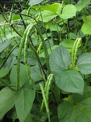
First harvest
Originally uploaded by gerald_belton
We moved in to the new house in June, and one of the first things I did was start a garden. Today the first produce from that garden was ready -- cowpeas, aka blackeye peas. I got a little over a pound (after shelling) from 20 square feet of garden. There are still a bunch left that aren't ready yet. If they ripen before the frost hits, there will probably be another pound.
An afternoon of geocaching and benchmark hunting
Saturday afternoon I wanted to do some caching, but I also needed to get my car inspected and the oil changed. It turns out that Jiffy Lube has free WiFi, so I fired up GSAK and loaded some waypoints into my laptop. When my car was done, I started with the nearest waypoint:
FY1903 WITCH
An easy benchmark to get started. It's at the edge of the parking lot of a restaurant supply company. Someone has painted a big arrow on the pavement, making it hard to miss. (Incidentally, I realized at this point that I had forgotten my digital camera. I was stuck making photographs with my Blackberry.)


The datasheet says it's flush with the surface... but I had to clean a half-inch of dirt off it. The datasheet also says it's marked "WITCH," but it actually says "WITCHY."
Next on the list were a couple of geocaches. Two quick park n' grabs in the same parking lot.
GC14A06 Pole Position
GCIW18T At the Crossing
After signing those two logs, it was on to search for a benchmark. FY1904 FRASIER. The last recovery for this one was in 1977, and the NC Geodetic Survey reported it as DNF in 1994. The coordinates are "Adjusted" so they should be spot on. And they place it right in the right-turn lane of N. Duke St. All of the reference points mentioned in the description are gone. I can only conclude that the mark was destroyed when Duke Street was widened, sometime between 1977 and 1994.
FY1905 CARVER was a pleasant surprise...I was looking at the NGS datasheet, and not the logs on geocaching.com. The 1994 recovery note says "mark is now recessed 8 inches below the ground." I was expecting to log a DNF because I wasn't equipped to dig, but I found it at the bottom of a hole in the ground.

After a couple of benchmarks and a couple of microcaches, I was ready for a bigger geocache. One where I could leave a trade item and take a souvenier. On to GCTYX4, named in honor of one of my favorite ex-Presidents. The container was big enough to leave something, but I didn't... everythig inside was a soggy mess and smelled of mildew. But it was a nice spot to visit, and a good hiding spot.
I looked for two more benchmarks, FY1906 and FY1907, both of which seem to have been lost to the widening of North Duke Street.
My final geocache of the day was part of the Caches for Wolves series: GC18QP6. This was yet another log-only microcache, but it was fun finding it. It was hidden in a way I had not seen before.
It was nearly time to head for home, but I had one more stop to make on the way home: FY2936 CASH. I had attempted this one once before, but using the GPS built in to my Blackberry. The description says it's "flush with the surface of the ground" but I couldn't find it. Armed with a better GPSr, and a long screwdriver for probing in the ground, I was hopeful of making a recovery.
Most of the reference points listed in the description are gone. There is no fence and no house. But the mark on the utility pole is still there.

And another mark has been painted on the road:

The datasheet mentions a dirt driveway... it appears to have been paved but not moved. Given all of this data, I have a pretty good idea of where this mark should be. But lots of probing with the screwdriver failed to locate it. It's either been destroyed or buried. If I ever get a metal detector this is going to be one of the first places I use it.
Friday, September 11, 2009
Innumeracy in the news
I was half asleep while watching the news this morning, but halfway through my first cup of coffee this story caught my attention:
Customers speak out about Duke Energy rate increase
"Raleigh, N.C. — Duke Energy customers voiced their concerns on Thursday night about a planned 13.5 percent rate increase.
"Under the plan, people with an average monthly bill of $100 a month would go up about $18."
I hate to pick on my friends at WRAL, but how did that get on the air?
WNCN says the increase is 12.6% -- and their math works out:
"The utility wants a 12.6 percent hike, which would be an additional $150 a year for a household that currently pays about $100 a month."
WTVD also says the rate hike is 12.6%, and claims that it's "about $11 per month." But they don't mention a base rate. If the average bill is around $87, then that works out.
Is the proposed rate increase 12.6%, or 13.5%? Is the average bill going up $11 per month, $150 per year, or $18 per month? Is $18 = to 13.5% of $100?
Wednesday, September 9, 2009
North Georgia Pastor Killed by Drug Warriors
Another Victim of the War On (some) Drugs:
Family seeks answers after N. Ga. pastor killed in drug sting
Read the story... it appears that this young pastor was leaving a convenience store when a black Escalade pulled into the parking lot, and a bunch of men in black t-shirts jumped out waving guns. He did what I would have done: he tried to get the hell out of there.
Yeah, they were yelling "Police! Stop!" But they were not wearing uniforms nor displaying badges. I'm sure no criminal would EVER yell "Police!" to get a victim to stop. And if he was in his car with the AC going and the radio on he probably couldn't hear them, anyway.
The surveillance video is posted on YouTube -- the freaking cops are wearing MASKS!
YouTube Video
Geotagging
I've been playing around with my GPS lately... geocaching, and hunting for benchmarks, and such. And I also enjoy photography and take a lot of pictures.
The camera on my Blackberry geotags photos with coordinates from its internal GPS, and after I upload them to flickr I can display them on a map, which is pretty cool.
The only problem is that as a camera, the Blackberry is a pretty good telephone. But using it caused me to wonder about geotagging images from a real camera. Flickr lets you drag and drop photos on to their map, but that depends on remembering where you took the photo and being able to find it on the map!
Software to the rescue! There is software out there that takes a track from your GPS, and uses it to tag photos with coordinates based on where you were at the time the photo was taken.
For starters, you need to get the tracks from your GPS to the computer. The software that came with my Garmin works fine for this. But EasyGPS is actually easier to use, and takes up less space on my laptop's tiny hard drive. (The only problem is that easygps doesn't display an actual map, but for our purposes that doesn't matter.)
There are several programs that will merge the track data with your photos. The one I use is Photomapper. (EasyGPS and Photomapper are both free.)
Here's a brief tutorial on geotagging your digital photos.
1) Set the clock on your digital camera. I had never bothered to do this before but it's important for this process. The time and date on your photos has to coordinate with the time and date on your GPS track, so make sure that your camera's clock agrees with your GPS!
2) Turn on your GPS. My Garmin eTrex automatically starts recording a track whenever it is turned on. If yours doesn't, then push whatever buttons it takes to make it start recording.
3) Go out and take some pictures!
4) Hook your GPS to your computer, and using either EasyGPS or whatever software came with your GPS unit, save the track. Photomapper accepts a number of formats for this, but GPS eXchange Format (.gpx) seems to be the most universal.
5) Upload your photos to your computer.
6) Start Photomapper.
7) The "File" menu in Photomapper has only three choices: Import GPS Data, Import Images, and Quit. You can probably figure out what to do from here, but I'll continue. Select "Import GPS Data" and load the .gpx file you saved in step 4. Then select "Import Images" and navigate to the folder with your pictures.
8) Photomapper then matches up the timestamps on the photos with the locations in your GPX track. It will show you a map (from Google Maps) with the locations of your photos, and a list of photos with latitude and longitude displayed.
9) Now click "tag selected images" and Photomapper will add the geotagging data to the image files. It also gives you the option to export them to Google Earth, but I don't because I'm going to upload them to Flickr.
If you are using Flickr, you'll need to set your account to allow the import of EXIF geotags when you upload images. Click this link to set this permission.
After that is done, you can upload the pictures. I saved my test run photos into a set, and viewed that set on a map. It came out looking like this:

If you'd like to see it "live," here's the link: Geotagging experiment map view
Subscribe to:
Posts (Atom)


